
3D LiDAR is becoming an essential driving force for transportation scenarios with its high precision and efficient data acquisition capabilities. It can produce an accurate 3D LiDAR mapping of the surrounding environment by using a pulsed laser light source to precisely measure distances.
In addition, 3D LiDAR has perfect performance in various challenging conditions such as darkness, inclement weather, and complex terrains. This unique and practical benefit has shown its usefulness as a powerful tool in the transportation industry, which is widely employed in highways, railways, civil aviation, water transportation, and industrial transportation.
In this article, we will discuss the major applications of 3D LiDAR in these 5 transportation fields, revealing how this technology is transforming the modern transportation system.
3D LiDAR Applications in Road Transportation
● Traffic Real-Time Monitoring
3D LiDAR sensors can monitor traffic flow instantly, offering precise data on vehicle speeds, densities, and patterns. As a result, traffic management systems can optimize traffic lights, route planning, and road usage, minimizing congestion.
● Accident Detection and Response
3D LiDAR plays a vital role in accident detection and response on highways. By scanning the surrounding area, a high-resolution LiDAR can recognize the blocked lanes or obstructions and report the information to traffic authorities. This function benefits to prompt detection of accidents or potential risks, allowing for responding swiftly and deploying emergency services.
3D LiDAR Applications Used in Railway Transportation
◆ Railway Intrusion Monitor
3D LiDAR sensors allow for the continuous 24-hour monitoring of the railway track environment. When animals intrude, or the railway line is affected by natural disasters such as falling rocks and mudslides, the system can immediately detect details such as the object’s size, distance, and velocity. By coordinating with the video cameras, it generates detailed data combining 3D point clouds and video images. In addition, 3D LiDAR can be connected with the unified dispatching platform and the train emergency braking system to form a closed-loop management, enhancing the safety of railway operations.
◆ Railway Freight Detection
3D LiDAR can conduct real-time scanning of freight trains, generating three-dimensional point cloud models. Based on these models, the system segments and analyzes various components to automatically identify and assess key inspection points. It can identify issues such as open doors or windows, foreign objects on the carriage, damaged or misaligned tarpaulins, and signs of overloaded or shifted cargo, boosting the effectiveness of freight car inspections and decreasing rail transport risks.
3D LiDAR Applications Used in Civil Aviation
Aircraft Docking Guidance
The traditional manual docking guidance system may face challenges in meeting the demands of modern airport operations due to its low efficiency, poor safety, and single function. The docking guidance system (DCS) uses 3D LiDAR to monitor the position, attitude, and speed information of aircraft approaching the berth. It helps the airport management to count the occupancy time of each berth, which is beneficial for arranging more aircraft landings and takeoffs, improving the utilization rate of the berth resources, enhancing safety, and reducing the flight delay rate.
Aircraft Ground Towing Collision Avoidance
Aircraft ground towing is an essential stage in the aircraft operation and maintenance process. During the operation, unsafe events and even accidents often occur due to human elements, environment, and other factors, resulting in equipment damage, flight delays, and other consequences. By equipping the tractor with a set of 3D LiDAR systems, it can promptly issue safety alerts to the aircraft towing staff. This allows airport workers to take appropriate measures based on different alert messages to avoid collisions with obstacles in the intrusion area, thus greatly reducing the occurrence of accidents.
3D LiDAR Applications in Maritime Transportation
✔ Channel Vessel Traffic Statistics
3D LiDAR provides real-time measurement and statistics of vessel traffic in the channel, operating 24/7. It automatically records the number, course, speed, length, width, and trajectory of passing vessels. This objectively reflects the maritime traffic situation, offering stable and reliable data support for the informatization of waterway construction.
✔ Proactive Collision Warning for Bridges
Due to the large size and tonnage, the maneuverability of ships on the water is limited. When ship operators detect an off-course that may pose a risk of collision with a bridge, they are often unable to stop and correct course in time. 3D LiDAR can promptly identify target ships threatening bridge safety and issue warning signals, significantly reducing the probability of ship-bridge accidents.
✔ Vessel Overlimit Detection
Affected by different flood seasons in the waterway, water levels fluctuate greatly. The various types and different shapes bring considerable difficulty to the monitoring of the clearance height. 3D LiDAR can accurately portray the contour information of the ships, identifying the highest point and timely issuing warnings for vessels that exceed the height and width limits, preventing them from passing through bridges.
3D LiDAR Applications in Industrial Transportation
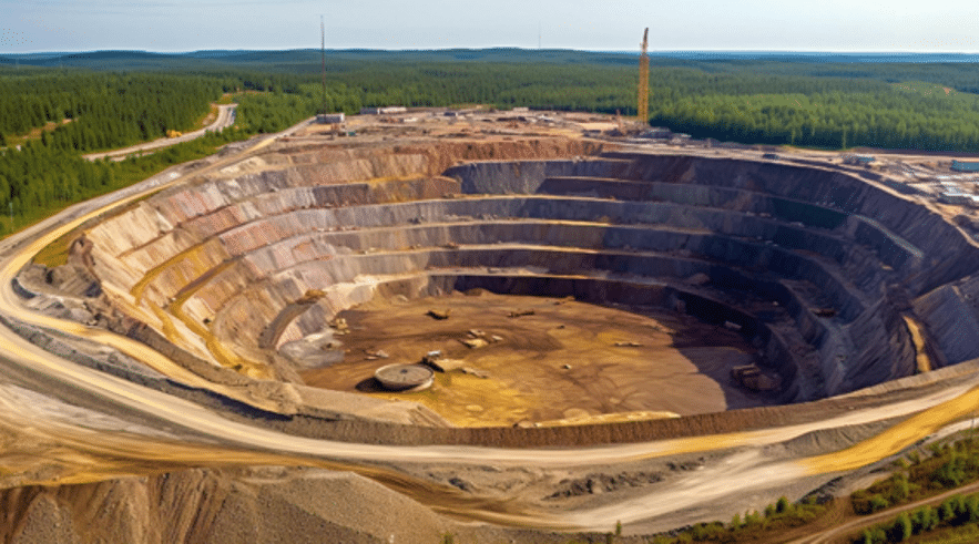
✧ Mine Site Topographic Mapping
3D LiDAR technology generated exact topographic maps of mining areas. 3D LiDAR sensors scan the terrain, obtain exact elevation data, and discover slopes and ridges. This information can back up to determine the optimal locations for mining activities and organize haulage routes.
✧ Self-driving Mining Trucks
The 3D LiDAR sensor can accurately measure the contour information of target objects and achieve centimeter-level precision detection for different types of obstacles. This enables the decision-making system to perform safe path planning and ensure operational safety. For example, during the operation, when encountering obstacles such as pedestrians or passenger vehicles, self-driving mining trucks can detect the status of obstacles ahead, effectively avoiding potential risks.
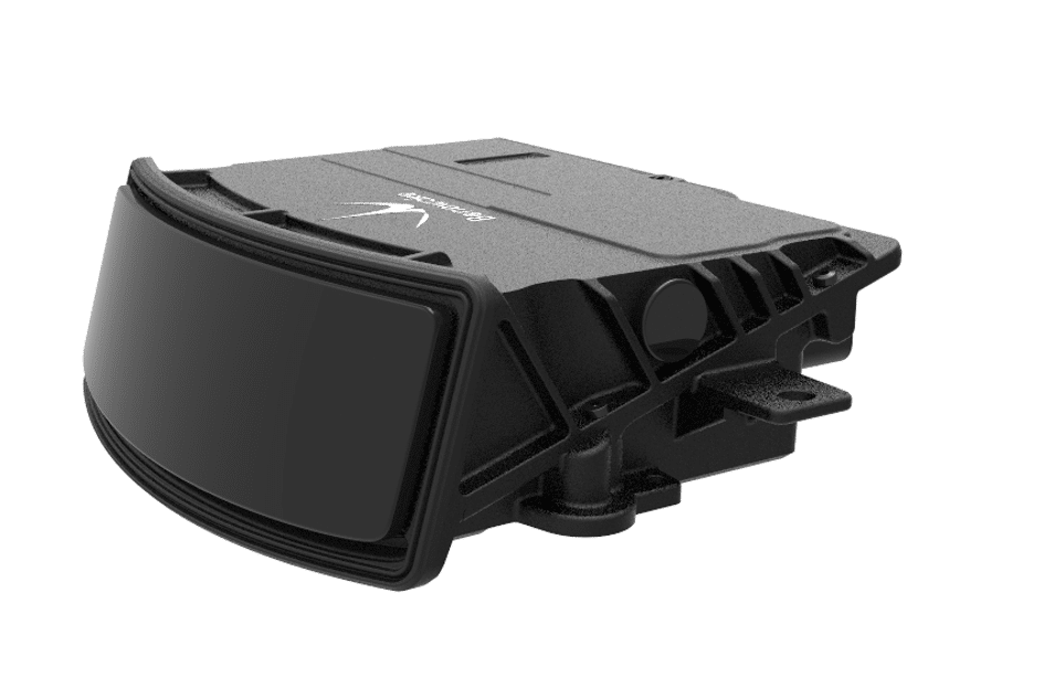
Introduction to Benewake’s 3D LiDAR
Considering the usage areas of 3D LiDAR in the transportation sector and the expectations of companies, Benewake’s AD2-S-X3 is by far the most preferred product.
■ High Resolution &Higher Sensitivity
Benewake’s AD2-S-X3 reaches a high resolution of 0.1° * 0.1°, which means it can distinguish targets at finer angles. In complex perception scenarios, such as busy intersections or dense air traffic, it can accurately differentiate every target object, ensuring that no object is confused or missed.
Higher sensitivity can make it respond to changes in the target more quickly. Regardless of the target’s moving speed, direction, or size, highly sensitive 3D LiDAR can quickly seize these changes. This ability is crucial for continuous traffic monitoring and warning systems, which can spot potential dangers in time and take corresponding measures to ensure traffic safety.
■ Long-Range Detection
The maximum detection range of Benewake’s AD2-S-X3 exceeds 350 meters. This long-range detection and tracking capability enables it to sense possible dangers or obstacles earlier, providing relevant systems or personnel with enough time to respond. For example, on highways or in complex traffic environments, radar systems can monitor long-distance vehicles and obstacles simultaneously and support drivers with timely warning information through intelligent analysis to avoid probable collision risks. Additionally, this advanced sensing capability can help optimize traffic flow management and increase road traffic efficiency.
■ Continuous Operation
Benewake’s AD2-S-X3 can be operated 24 hours a day, not affected by external lighting conditions. Under insufficient lighting conditions or severe weather conditions, traditional optical sensors can be severely affected, resulting in reduced detection capabilities. AD2-S-X3 can overcome these limitations and ensure reliable detection results in various environments.
Conclusion
Benewake’s 3D LiDAR technology has demonstrated its transformative potential in various transportation sectors, providing accurate and reliable data for safer and more efficient operations. Its applications in road, rail, air, maritime, and industrial transportation are reshaping how we manage traffic, maintain infrastructure, and assess resources.
When we evaluate the use and expectations of LiDAR in the transportation industry, Benewake’s AD2-S-X3 is the ideal choice. With the high resolution, sensitivity, and long-range detection capabilities, it presents high performance in all stages of transportation. Visit the Benewake to get to know the product better and examine all its features.