
As drones become more deeply integrated across various industries, from precision agriculture to infrastructure inspection, and from logistics delivery to security monitoring, their mission scenarios are growing increasingly complex.
In this trend, the need for high-precision and highly reliable perception of the surrounding environment has become an urgent and core requirement for drones. Traditional sensors like vision or ultrasonic often struggle in complex lighting, harsh weather, or when detecting unstructured obstacles. The market urgently requires a superior perception solution.
We will delve into why single-point LiDAR is an ideal choice for drones and recommend the most suitable LiDAR models for them.
Core Challenges Faced by Drones
1. Insufficient Positioning and Altitude Accuracy
- GPS signals are susceptible to interference in canyons and urban areas, causing positioning drift.
- Barometric altimeters are easily affected by wind, temperature, and airflow disturbances, failing to provide accurate above-ground-level (AGL) height.
2. Limited Obstacle Perception and Avoidance Capabilities
Particularly when facing objects difficult for cameras and ultrasonics to recognize, such as power lines, thin branches, and transparent glass, the autonomous flight safety of drones faces significant challenges.
3. Measurement Accuracy Issues in Specific Scenarios
For missions like precision landing, terrain following, or power line inspection, stable and accurate distance measurement to specific targets is required. Conventional sensors often fail to meet the millimeter-to-centimeter-level accuracy demands.
Why Single-Point LiDAR is an Ideal Solution
1. Key Advantages
- High Accuracy: The principle of laser ranging enables it to provide precise distance data at the centimeter or even millimeter level.
- High Frequency: Data update rates can reach thousands of Hertz, allowing real-time response to rapid changes in height and distance.
- Strong Anti-Interference Capability: Less susceptible to ambient light, smoke, dust, and electromagnetic interference, ensuring stable performance in complex environments.
- Low Cost: Compared to multi-line LiDAR, single-point LiDAR has a simpler structure and significantly lower cost, making it more suitable for large-scale adoption on consumer and industrial drones.
2. Primary Applications in Drones
- Altitude Hold and Hovering: Replaces unstable barometers to provide precise AGL height.
- Obstacle Sensing: Particularly effective for detecting obstacles below the drone or in specific directions.
- Precision Landing: Guides drones to land accurately on moving platforms or designated markers.
- Terrain Tracking: Maintains a constant AGL during operations like agricultural spraying or topographic mapping.
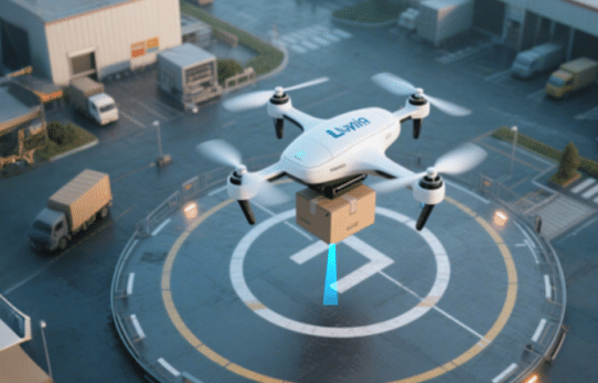
- Logistics Delivery: Precisely measures the distance to the drop point during delivery operations.
Key Factors to Choose a LiDAR Sensor for Drones
When selecting a single-point LiDAR for a drone, one must never focus on a single parameter, which requires a comprehensive trade-off among the following key factors:
1. Accuracy and Stability
It’s not just the nominal ±2cm or ±5cm. It’s crucial to pay attention to its performance across the full measurement range and under varying target reflectivity conditions. For instance, will the ranging accuracy significantly degrade for low-reflectivity objects (like black asphalt or coal)?
A sensor with high nominal accuracy but significant data fluctuation is equally useless. Its repeatability and long-term stability under vibration and temperature variations must be evaluated. An excellent single-point LiDAR should output smooth and reliable data even amidst drone motor vibrations and changing external temperatures.
2. Weight and Size
For multi-rotor drones, particularly small and medium-sized models, every additional gram of weight directly translates into reduced flight time. Moreover, a compact and lightweight design enables seamless integration into the drone’s body or onto custom mounts, which in turn minimizes wind resistance and helps maintain a stable center of gravity.
3. Power Consumption and Heat Dissipation
The power consumption of a single-point LiDAR directly impacts the overall system’s power budget. High power consumption drains precious battery capacity and generates significant heat. Inadequate heat dissipation can cause the sensor to overheat during prolonged operation, particularly in high-temperature environments, leading to performance degradation (such as a declined range) or even permanent damage.
4. Environmental Adaptability
- Resistance to Ambient Light Interference: This is a paramount requirement for outdoor applications, as inferior sensors may experience complete ranging failure or a significant increase in noise under intense sunlight.
- Weather Resistance: Despite the general performance degradation of LiDAR sensors in harsh weather, a superior model should maintain a degree of functionality. It’s critical to assess the effective range attenuation under varying conditions, such as rain or snow.
- Measurement Range and Field of View: The appropriate measurement range must be selected based on the specific application, with simultaneous consideration given to the sensor’s effective field of view to ensure comprehensive coverage of the required detection area.
5. Data Output Frequency and Interface Compatibility
A higher output frequency enables the flight controller to receive distance data with lower latency, facilitating faster and smoother control responses.
The single-point LiDAR should feature common interfaces like UART (TTL/RS232/RS485) or I2C that are easily compatible with the flight control system. Furthermore, an open, well-documented, and easy-to-parse data protocol is essential for streamlining development and integration.
6. Safety and Certification
The LiDAR sensor must clearly specify its safety classification. Single-point LiDAR units for drone applications should typically be Class 1 (safe under all conditions of normal use), ensuring no risk of harm to people or animals on the ground.
Verification of necessary industry certifications, such as CE, FCC, and RoHS, is recommended as they attest to product quality, safety, and regulatory compliance.
Best LiDAR for UAV/Drone in 2025
Based on core performance parameters, market validation, and overall cost-effectiveness, we have selected the best single-point LiDARs suitable for drone platforms in 2025. The following products are divided into two main categories: Benewake, representing high-cost-performance, mass-produced models, and Lightware, displaying specialized professional-grade performance in specific areas.
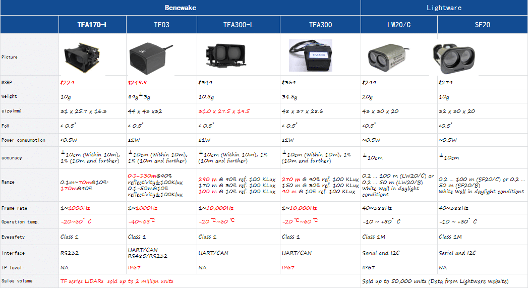
1. Benewake TF170-L
- Key Advantage: Its standout feature is an ultra-long 170-meter range (for 40% reflectivity), designed specifically for high-speed, large industrial drones.
- Key Parameters: Weighs only 10g with a power consumption of less than 0.5W, balancing long-range capability with strict drone payload requirements. It’s 1000Hz frame rate adequately meets the control response needs of high-speed flight.
- Applications: Logistics delivery, power line inspection, large-area topographic surveying, and tracking.
2. Benewake TF03
- Key Advantage: Offers an excellent balance of range, environmental adaptability, and ruggedness. With a board operating temperature range of -40°C to 85°C and an IP67 rating, it is a true all-weather warrior.
- Key Parameters: 150-meter range (40% reflectivity), and can still detect low-reflectivity objects (10%) at 50 meters under strong ambient light (±100 Klux), making it highly practical for outdoor use.
- Applications: Agricultural spraying, security patrols, inspection, and general drone altitude hold and obstacle avoidance.
3. Benewake TFA300 Series
- Key Advantage: The TFA300 series represents Benewake’s top-tier performance, available in two options: TFA300 (Standard) and TFA300-L (Lightweight). The most notable feature is the ultra-high 10,000Hz frame rate, enabling applications requiring extreme control frequency for research or special purposes.
- Key Parameters:
(1) TFA300-L: Weighs just 10.5g with a range up to 270 meters (40% reflectivity), representing the perfect blend of performance and lightweight design.
(2) TFA300: Shares the same range as the L version but in a more robust housing with an IP67 protection rating.
- Applications: High-speed autonomous drones, precision scientific measurement, and missions requiring very high data update rates.
4. Lightware LW20/C
- Key Advantage: The Lightware brand is well-regarded in professional surveying for its high measurement accuracy and stability.
- Key Parameters: Has a 100-meter range (white wall, daylight conditions), rich interfaces (Serial and I2C), and an IP67 rating. Note that its frame rate (40-380Hz) and operating temperature range (-10~50°C) are somewhat narrower compared to Benewake products.
- Applications: Precise terrain modeling, scientific data collection, professional aerial surveying with stringent altitude hold accuracy requirements.
5. Lightware SF20
- Key Advantage: As a compact and lightweight alternative to the LW20/C, the SF20 facilitates a minimal weight of 10g
- Key Parameters: Matches the same range as the LW20/C but in a more compact package. A drawback is the lack of an IP rating, requiring careful consideration of the operating environment.
- Applications: Consumer-grade drones, altitude hold for small commercial drones, precision landing.
Wrapping-up
As drone applications diversify, the demand for reliable single-point LiDAR has never been greater. While several manufacturers have developed high-performance products, Benewake LiDAR series is the optimal solution for users prioritizing extreme cost-effectiveness and large-scale deployment, as evidenced by the TF series selling over 2 million units globally.
- For missions demanding ultra-long measurement ranges, the TF170-L or TFA300 series are the recommended choices.
- For operations in extreme environments, the TF03 proves to be the superior option.
By thoroughly evaluating specific application needs and matching them with the appropriate LiDAR capabilities, users can significantly enhance their drones’ perception, ensure operational safety, and unlock new potential across diverse scenarios.