
The real estate industry has always been about three things: location, location, location. But in 2025, there’s a fourth element revolutionizing property transactions, development, and management—and most professionals still underestimate it.
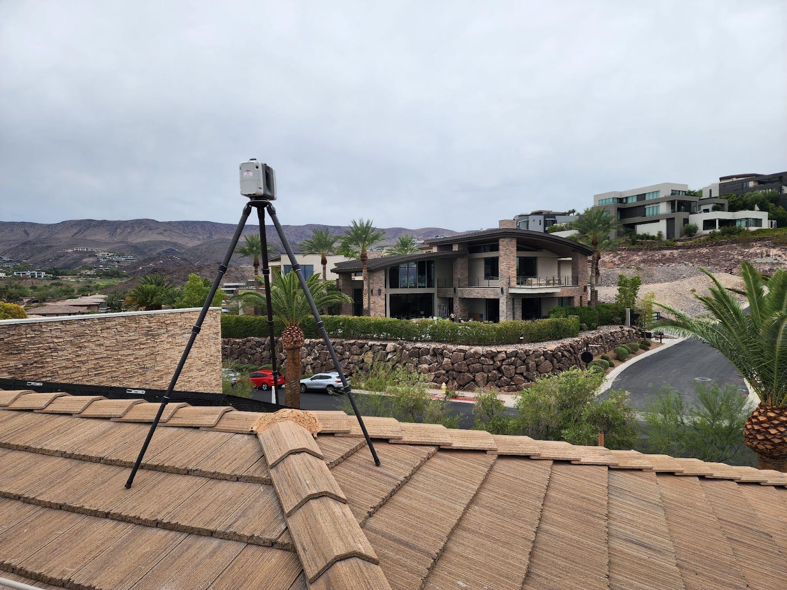
LiDAR (Light Detection and Ranging) technology, the same system powering self-driving cars and urban mapping, is now transforming how properties are surveyed, valued, and verified.
What once took surveyors weeks with tape measures and manual drawings now happens in hours—with millimeter-level precision. The implications for property developers, brokers, and asset managers are profound.
What Exactly Is LiDAR, and Why Should Real Estate Professionals Care?
Think of LiDAR as a high-resolution radar for buildings. It emits millions of laser pulses per second, measuring how long each beam takes to return from a surface. The result? A 3D point cloud—a precise digital twin of the environment, accurate to within 1–3 millimeters.
This isn’t a 360° photo tour—it’s an engineered dataset used by architects, appraisers, and construction teams.
To learn how professional scanning can transform your property documentation, visit LiDAR Precise Plans for expert 3D laser scanning and LiDAR as-built services.
Learn how LiDAR as-built drawings are redefining accuracy and efficiency in property documentation.
The Traditional Survey Problem: Time, Cost, and Inaccuracy
Traditional property surveys rely on manual measurements, hand sketches, and on-site guesswork. For a 5,000-square-foot building, it can take days—sometimes weeks—to collect data and produce 2D drawings that may still contain critical errors.
These inaccuracies directly affect square footage calculations, rental rates, and property valuations—issues that LiDAR technology eliminates entirely.
Discover how 3D scanning eliminates traditional survey errors that often inflate project costs and delay approvals.
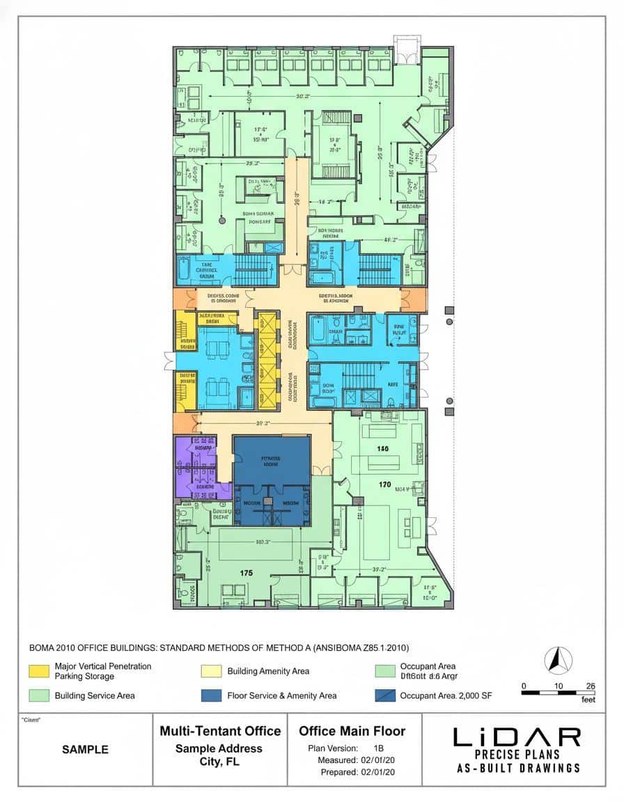
How LiDAR and BOMA Standards Are Changing Property Measurement
Speed and Efficiency
A LiDAR scan of a 5,000-square-foot property takes about 2–3 hours, including setup. By comparison, traditional surveys might require two to three full days. That’s why LiDAR scanning in Phoenix and commercial LiDAR scanning services in Los Angeles has become the go-to method for developers who want faster, verifiable site documentation.
Unmatched Accuracy Meets BOMA Compliance
LiDAR scanners capture data with 1–3 millimeter precision—a level of accuracy that matters immensely in real estate scenarios where measurements determine property value, leasing potential, and construction feasibility.
But precision alone isn’t enough; measurements must also align with accepted industry standards. That’s where the BOMA (Building Owners and Managers Association) standards come in.
BOMA defines the official methodology for measuring rentable and usable square footage in office, industrial, and mixed-use properties. When LiDAR scanning is combined with BOMA-compliant area calculations, the result is a new gold standard:
- ✅ Transparent square footage reporting
- ✅ Verified rentable vs. common area delineation
- ✅ Reduced disputes during leasing or sale negotiations
By integrating LiDAR with BOMA measurement standards, property professionals ensure that their space data is both technically precise and legally consistent—a combination that’s reshaping how portfolios are valued and managed nationwide.
Comprehensive Digital Documentation
Unlike traditional surveys that only capture what someone chooses to measure, LiDAR records every visible surface—walls, columns, soffits, windows, beams, and mechanical systems—into a permanent digital archive.
When paired with Revit modeling or CAD as-built drawings, this creates a living record of the property that supports future renovations, audits, and maintenance.
Real-World Applications Transforming the Industry
Property Marketing and Leasing Accuracy
Commercial brokers in Los Angeles and Denver now use LiDAR-based, BOMA-verified measurements to market properties with confidence. Buyers and tenants can view accurate rentable square footage data alongside immersive 3D walkthroughs.
Construction and Renovation Planning
Architects and contractors import LiDAR data directly into Revit or AutoCAD, ensuring new designs perfectly align with existing conditions. Firms using LiDAR as-built services in San Francisco report fewer redesigns and faster approvals.
Historic Preservation and Asset Documentation
For landmark buildings, LiDAR provides an irreplaceable record. Historic property owners in San Francisco and Pasadena use LiDAR to document façades and interiors to within sub-centimeter accuracy, ensuring architectural integrity for generations.
The Future of Real Estate Measurement
LiDAR represents more than just a new tool—it’s a paradigm shift in how the built environment is measured, valued, and understood.
When combined with BOMA standards, LiDAR creates a unified, verifiable framework that eliminates measurement disputes and brings absolute clarity to every square foot of real estate.
The question isn’t if LiDAR will become the industry standard—it’s how quickly your organization will adopt it and start reaping the benefits.
Discover how LiDAR Precise Plans helps real estate professionals capture existing conditions with unmatched speed, precision, and BOMA compliance.
If you’re planning a renovation, addition, or home upgrade, don’t start blind. Our residential as-built drawings give you the accurate documentation needed to move forward confidently.
- Let’s talk about your home project
3D scanning services in the following major markets:
- Las Vegas 3D Scanning Services
- San Francisco 3D Scanning Services
- Los Angeles 3D Scanning Services
- Phoenix 3D Scanning Services
- Denver 3D Scanning Services
- Austin 3D Scanning Services
- Utah 3D Scanning Services
Each of these locations offers fast mobilization, expert documentation, and
personalized deliverables tailored to your needs.Visit us at www.lidarasbuiltdrawings.com